Buying land near Liberty can feel simple at first. You see a beautiful tract, the price per acre looks fair, and you start picturing a homesite, a small farm, or a long-term investment. But before you fall in love with the view, you need to know what you can actually do with the land, how you legally reach it, and how much of it is truly usable. That is where careful local due diligence makes all the difference. Let’s dive in.
Start With Jurisdiction First
One of the first questions to answer is whether the property sits inside the City of Liberty or in unincorporated Pickens County. That matters because the rules can change depending on which jurisdiction controls the parcel.
Inside Liberty city limits, the city’s zoning map is the key reference for zoning status. Liberty’s zoning districts include residential, commercial, and industrial categories, and those classifications affect what uses may be allowed on the property.
If the land is outside the city, Pickens County’s planning and development code becomes especially important. County rules can shape subdivision standards, road access, easements, plats, and stormwater review, even when a parcel looks rural and unrestricted at first glance.
Why the Boundary Check Matters
Sometimes the line between zoning districts is not obvious from a quick online map view. Liberty’s ordinance says that when a zoning boundary is uncertain, district lines generally follow street centerlines or platted lot or tract lines.
That means you should compare the zoning map with the recorded plat and GIS information before making assumptions. A small difference on paper can affect how you plan to use the property.
Zoning Tells You What Comes Next
Zoning does not answer every question, but it sets the stage for almost all of them. If you are thinking about building, dividing land, or using acreage for a specific purpose, zoning is one of the first filters to check.
For land near Liberty, this step is especially important because city and county standards can be very different. A parcel that seems ideal for one plan may involve extra review or limitations once access, drainage, or development standards come into play.
Use More Than One Record Source
A smart land buyer does not rely on a single screenshot or listing description. The Pickens County Assessor’s office provides access to GIS data, maps, real property search tools, sales search, and deeds and plats search, which makes it a practical starting point for parcel research.
At the same time, county records include a public disclaimer that online accuracy and reliability are not guaranteed. If the details matter to your purchase decision, confirm the recorded deed or plat rather than depending only on what appears online.
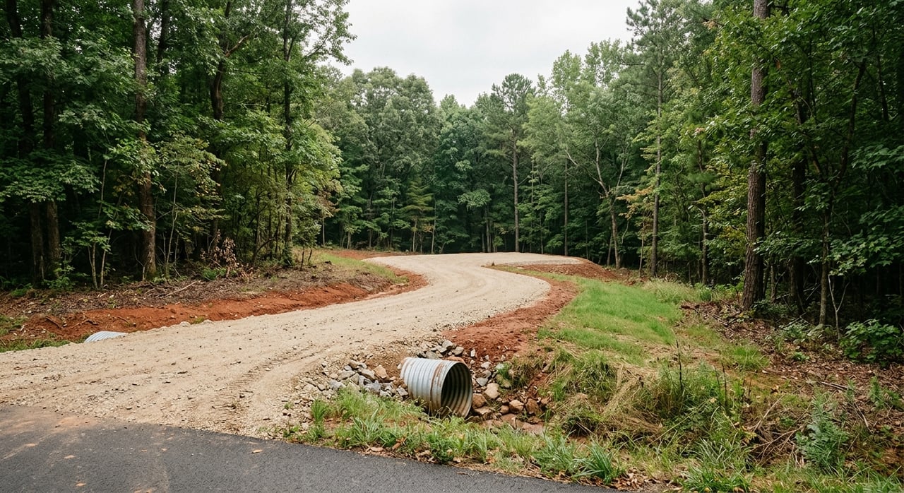
Access Can Make or Break a Land Purchase
A tract can have road frontage on paper, a driveway in the field, or a path across neighboring land, but those are not always the same thing. In Pickens County, every development and every lot in a subdivision must have access to the public street system through a standard county road or an approved private street.
The county also states that a building permit cannot be issued unless continuous road access is provided. In other words, access is not just a convenience issue. It can directly affect whether you can build at all.
Legal Access vs. Informal Access
This is where buyers often get surprised. A property may look accessible because someone has been driving across it for years, but that does not necessarily mean the access is legal, approved, or sufficient for a permit.
For subdivision-style land, details like road naming, address assignment, and some plat requirements run through county E-911 and planning staff. A road that physically exists may still need legal or administrative approval to function the way you expect.
Driveway Rules Matter Too
Driveway access also deserves a close look. Pickens County limits direct driveway access for residential lots in major subdivisions to county major collectors, county arterials, or state and U.S. numbered highways unless the county engineer or SCDOT approves it.
For state-maintained roads, SCDOT says residential owners request a driveway apron through the local office. Commercial driveway aprons are handled through an encroachment permit. If your plans depend on a new entrance, this is worth checking early.
Easements Affect Usable Land
Before you focus on price per acre, read the easements. Easements can reduce where you build, where you place utilities, and how much open land you can actually use.
Pickens County requires utility and drainage easements to be shown on plats and deeds. Water and sanitary sewer easements must be at least 20 feet wide, while combined utility easements must be at least 30 feet wide. Drainage easements outside the street right-of-way must also be clearly defined.
Why Easements Change Value
A 10-acre parcel is not always 10 usable acres. Easements, access areas, flood-prone sections, and drainage features can all limit building options and reduce flexibility.
That is why experienced land buyers compare usable acres, not just total acres. In many cases, the better value is the tract with fewer total acres but fewer constraints.
Water, Sewer, Septic, and Wells
Utilities should be checked early, not after you are under contract and emotionally committed. South Carolina’s environmental guidance advises buyers to contact local government before buying land to determine water and sewer availability.
If the property is inside Liberty city limits, verify whether municipal water and sewer service is available and what connection costs may apply. The City of Liberty maintains its own utilities department along with water and sewer services.
Septic Approval Is a Separate Step
If public sewer is not available, septic feasibility becomes a major part of your decision. South Carolina requires a permit to construct and operate any new, upgraded, or expanded septic system before construction, and the home site must be evaluated before the permit is issued.
That means a parcel is not automatically buildable just because nearby homes have septic systems. Soil, site conditions, and the specific homesite layout all matter.
Wells Have Their Own Process
Private wells follow a different track. South Carolina says individual residential and irrigation wells require a Notice of Intent before construction, must be drilled by a South Carolina-certified well driller, and are reviewed within 48 hours after a complete Notice of Intent is received.
It is also important to know that private well owners are responsible for testing and treating their own water. If you are planning a rural homesite, that responsibility should be part of your budgeting and planning.
Plats, Aerials, and Surveys Each Have a Role
Online maps and aerial images are helpful, but they are not final proof of boundaries. The Pickens County Assessor’s office specifically notes that it cannot determine a fence line.
If a boundary is disputed or exact lines matter to your plans, a private surveyor is usually the right next step. Plats and aerials are useful clues, but they are not substitutes for a survey when precision matters.
Check for Consistency
A practical way to review land is to compare several sources side by side:
- Deed description
- Recorded plat
- Assessor map
- Aerial image
- Visible access points and road frontage
If those records all point to the same boundaries and access pattern, you can move forward with more confidence. If they conflict, pause and resolve the issue before you commit.
Physical Conditions Influence Value
Land value is about more than size and location. Pickens County subdivision standards warn that land physically unsuitable because of flooding, poor drainage, topography, geology, or similar issues should not be approved for subdivision or development unless the problem is solved.
In practical terms, low spots, steep slopes, and wet soils can affect both buildability and market value. A beautiful tract may still have limited usable area once those conditions are considered.
Think in Terms of Usability
When you compare parcels near Liberty, ask yourself how much of the land can realistically support your goals. If you want a homesite, you need suitable access, a buildable area, and a workable utility plan.
If you want long-term value, buyers after you will likely ask the same questions. Strong access, clear boundaries, and fewer site constraints often support stronger resale appeal.
Agricultural Use Value May Affect Taxes
For some buyers, tax treatment is part of the value equation. Pickens County says bona fide agricultural real property may be taxed on use value rather than market value, generally at a 4 percent assessment ratio for qualifying individual or partnership owners.
The agricultural application period runs from January 1 through January 16 of the following year. If you are buying land for agricultural use, this is a detail worth reviewing early so you understand whether the parcel may qualify and how that could affect carrying costs.
A Smart Land-Buying Checklist Near Liberty
Before you buy land near Liberty, make sure you can clearly answer these questions:
- Is the parcel inside Liberty city limits or in unincorporated Pickens County?
- What zoning applies to the land?
- Does the tract have legal and continuous road access?
- Are there driveway approval issues to review?
- What easements appear on the deed or plat?
- Is public water or sewer available?
- If not, is the site likely to support septic and a well?
- Do the deed, plat, assessor map, and aerial image align?
- How much of the land is truly usable after drainage, topography, or flood-related constraints?
- Could agricultural use value affect the property’s tax treatment?
Local Guidance Helps You See the Whole Picture
Land purchases often look straightforward until the deeper questions start coming up. Zoning, access, utilities, and physical site conditions can all shape whether a tract fits your goals and whether the asking price makes sense.
When you work with a local team that understands Pickens County land, you can spot issues sooner, ask better questions, and move forward with more confidence. If you are thinking about buying acreage near Liberty, connect with Southern Real Estate and Development, Inc. for practical, local guidance tailored to your next move.
FAQs
What zoning rules apply to land near Liberty, South Carolina?
- The answer depends on whether the property is inside the City of Liberty or in unincorporated Pickens County. Inside the city, Liberty’s zoning map controls zoning status. Outside the city, Pickens County planning and development rules become especially important.
What kind of access does land near Liberty need before you can build?
- Pickens County requires continuous road access, and a building permit cannot be issued unless that access is provided. Access should connect to the public street system through a standard county road or an approved private street.
How do you check water and sewer service for land near Liberty?
- Start by confirming whether the property is inside Liberty city limits and whether city water and sewer service are available. If public service is not available, you should review septic and well requirements early in the process.
What should you know about septic systems for land in Pickens County?
- A permit is required before constructing and operating a new, upgraded, or expanded septic system, and the homesite must be evaluated before the permit is issued. Septic feasibility should be checked before you assume a parcel is buildable.
Do private wells near Liberty require approval?
- Yes. South Carolina says individual residential and irrigation wells require a Notice of Intent before construction and must be drilled by a South Carolina-certified well driller.
Why do easements matter when buying acreage near Liberty?
- Easements can reduce where you build and how much of the land is truly usable. Utility and drainage easements should be shown on plats and deeds, so they should be reviewed before you judge value by acreage alone.
Can online parcel maps confirm property boundaries in Pickens County?
- No. Online maps, plats, and aerials are helpful research tools, but they are not a substitute for a survey when exact boundaries matter. The Assessor’s office notes it cannot determine a fence line.
Can agricultural use value lower property taxes on land in Pickens County?
- It may. Pickens County says bona fide agricultural real property may be taxed on use value rather than market value for qualifying owners, which can affect the property’s tax treatment.